5
OVER THE POLE:
Surveying the Ice Ages from a Seat in Heaven
The human psyche has frequently been compared
to an iceberg. And in the early days of the polar
flight from Copenhagen to California, when
planes were smaller and still flew low enough and
slow enough for the passenger to see something,
there was a wonderful sight along the way.
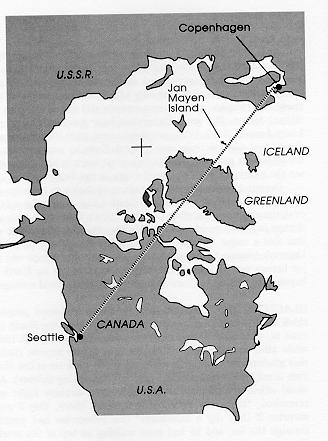
Crossing the Denmark Strait between Iceland and
Greenland, you looked down on icebergs floating
south. Each was a white jewel glittering in the
low northern sun, and were you a passenger
viewing the icy mountain from a ship's deck, this
would be all that you would see. But from one's
window in heaven you saw far more. Painted
turquoise by the waters, the immense underwater
mass of the iceberg spread all about beneath your
eyes. Majestic the frosty mountain of ice might
be; but hidden in mighty mystery was the force
that supported it. And such is the unconscious
mind.
the dramatist Robert Ardrey, 1969
Rather than
timeless, my "over the pole" flight turned out to be a journey
backward in time, as I surveyed the land covered and
uncovered by the ice ages. It seems strange to realize that
only 150 years ago, hardly anybody knew about the ice ages --
even scientists still talked in terms of a biblical deluge. The
great Swiss (and later American) naturalist, Louis Agassiz
(1807-1873), established about 1840 that massive ice sheets
had pushed their way around Europe, sometime in the not-so-distant past. He also wrote a great work in biology, sorting
out the relationships of the fossil fishes to the living species.
Despite this major discovery about evolution in
geology, plus the major theoretical feat in classification that
paved the way for evolutionary understanding, Agassiz didn't
believe in biological change in the Darwinian sense. He was
the last creationist who was also a major biologist, and was
bitterly opposed to Charles Darwin's interpretation of how
species evolved. Perhaps one major heresy per lifetime
(extending the span of life on earth far beyond the biblical
scholars' estimate) was all he could manage.
GLACIERS DESCENDING from the north lead most
people to think that the center of the ice cap must have been
the North Pole (that is, after all, the way it works at the South
Pole). It took a while after the discovery of the ice ages
before anyone realized that glaciers don't form over open
ocean: the pack ice at the North Pole is only a few meters
thick (and it's rapidly getting thinner). As a naval officer
sitting next to me on another airplane flight once remarked, "If
anyone ever builds a house there, they'll get a surprise if they
dig a basement!" (his submarine had punched through the ice,
and he had gone walking on top of the world). The bottom of
the Arctic Ocean is as deep as the Atlantic. It has features
such as Nansen Basin, underwater ridges such as the Nansen
Cordillera; both are named for the Norwegian scientist Fridtjof
Nansen, one of the first neurobiologists. In 1888, Nansen and
the Spanish neurobiologist Santiago Ram�n y Cajal
simultaneously discovered "the neuron doctrine"; Nansen was
later an arctic explorer in 1893 to 1896, still later a diplomat
who received the Nobel Peace Prize in 1922.
Although it may snow up on top, the sinking ice
changes back into water on the submerged surface of the ice
sheet. To build up ice to the thickness of a mountain range,
as happens during an ice age, requires a solid foundation such
as Greenland. Down at the South Pole, there is a whole
continent (9.3 percent of the Earth's land surface) to house glaciers; they have even spread out into some shallow bays
and displaced the seawater, e.g., the Ross Ice Shelf.
Greenland is about the only such land at high latitudes in the
northern hemisphere, although it is smaller than Europe (it
usually looks bigger because the high latitudes get stretched on
most maps).
When an ice age really gets going, then the northern
hemisphere has a lot more land on which to house glaciers
than the southern. Glaciers often came down to 50°
latitude (past London and Vancouver), but to 40° in a
few places (such as New York City and Woods Hole).
Between 50° and 70° latitude, the southern
hemisphere has only the tip of South America plus a bit of the
Antarctic Peninsula -- but the northern has Greenland, northern
Europe, the vast expanse of Siberia, and then Canada too. It
also has Alaska, but surprisingly the interior of Alaska north
of the coastal mountain ranges had few glaciers, probably due
to the "rain shadow."
FLYING OVER OSLO, one suddenly notices that the
flatland appearance of the Baltic has given way to rock -- an
ancient eroded landscape, the shallow valleys filled with
agriculture. Oslo sits at the head of a long fjord; though at
60° latitude, higher than Scotland, it is warmed by the
North Atlantic Current and its harbor usually remains as ice-free as New York City's (at 40° latitude).
A little further north at 65°, the vegetation is
very thin. There is little topsoil in the uplands, except in some
of the grooves (only 1 percent of Norway is agricultural, with
another 2 percent as grassland). This area has been repeatedly
scoured by glaciers, right down to bedrock. This is not only
some of the oldest rock in Europe, it is some of the earliest
rock anywhere on Earth. The deep grooves are not scrape
marks in the manner of the scratches made by boulders carried
along by the advancing glaciers; rather they are the result of
a billion years of erosion of the granite and gneiss by water
runoff.
Snow remains in some of the shadowed grooves,
sheltered from the oblique sunlight at these latitudes, giving
this part of Norway a zebra-striped appearance during some
seasons. This is the 65° latitude (the same as Iceland)
that Milutin Milankovitch used as the reference latitude for his
thesis developed in Budapest: elaborating on the 1842
suggestion of the French mathematician Joseph A. Adh�mar,
Milankovitch proposed that the sunlight reaching such latitudes
controlled the ice ages. He showed that in the warmest times,
there was as much sunlight here at 65° as there is
presently at 49° (e.g., Paris). In the coldest periods,
65° got about as much sunlight as they get today up at
76° (e.g., Thule, Greenland -- as far north as we'll fly in
going "over the pole" today). So sometimes Iceland has had
as much sunlight as Paris, and sometimes as little as Thule
(that hadn't been "intuitively obvious" until the calculations
were done).
The winds blow, and the rivers flow, their patterns and
strengths mostly a matter of seasonal sunlight.
THE NORWEGIAN UPLANDS are interrupted by fjords,
where some of the deeper grooves go out to sea. The one to
our left has a steamer ship heading inland, leaving behind a
long white wake in the fjord. A road cuts into the bordering
hillside of otherwise unrelieved rock.
An hour after leaving Copenhagen, we finally depart
Europe. We're now out over the Norwegian Sea, to be exact.
We will miss seeing Iceland, as our route takes us well to the
north. We have reached the latitude of the Arctic Circle; were
this midwinter, the sun would barely be peeking over the
southern horizon at noontime. Near midsummer, the sun
doesn't set, merely skimming the northern horizon at midnight.
We do see the mid-ocean ridge, where the ocean floor
is spreading apart as new material upwells from the depths of
the earth. There are some volcanos along that ridgeline:
Iceland's are the best known, but now we see Jan Mayen
Island out the right window, its volcano Beeren Berg poking
up through the clouds. Its glaciers have receded most of the
way back to the uppermost cone; they can't go very far before
reaching the sea -- except to the south, where the mid-Atlantic
ridge has poked up above the waters to form a long spit, like
the handle on a frying pan. The island resembles a Hawaiian
volcano, arched like a shield or convex lens -- except for the
top half, whose erect cone sweeps upward like the tip of
Japan's Fujiyama.
THE TILT OF THE EARTH'S AXIS of rotation, relative
to the plane of its orbit (in the arcane astronomical
terminology, "the obliquity of the ecliptic"), changes some
over the years. It drifts back and forth between 22° and
24.5°, taking about 41,000 years to make a complete
circuit. Currently the tilt is about 23.4° (and declining)
-- and at that latitude the sun stands overhead on the longest
day of the year. We northern hemisphere types call this
latitude the Tropic of Cancer; it passes just north of Havana,
Cuba. At maximum tilt, which last occurred about 9,600 years
ago, the sun makes it up to Key West, Florida; at minimum,
it only makes it up to the Isle of Pines off the southern coast
of Cuba.
This 2.5° may not seem like much (only the
difference in latitude between New York and Washington,
D.C., or between Geneva and the Mediterranean). But if you
live up where the glaciers do, you can get a considerable
percentage improvement in the warmth delivered in
summertime. The sun climbs a little higher in the sky at
midday, stays above the horizon a little longer to make the
nights even shorter.
Trying to reason out the physics of all this? A little
knowledge of physics can be misleading when it comes to ice
ages. The heat exchange involved in freezing and melting a
tray of ice cubes is identical -- so a change in tilt that
produces both hotter summers and cooler winters shouldn't
make much difference in ice buildup, right? But that analysis
assumes nothing moves -- and ice can move. The Atlantic
Ocean beneath us is full of icebergs, calved off of Greenland
and floating south, the warming job being exported to warmer
latitudes than where the snow fell and froze into ice atop
Greenland.
And this is the northernmost extreme of the North
Atlantic Current we're flying over. It is nice and warm,
flowing up as it does from the tropics. The North Atlantic
Current warms up all that cold Arctic air that flows east from
Canada, and so Europe gets much more comfortable weather
than they get at comparable latitudes in Canada (all of Europe
north of the Paris-Prague line is at Canadian latitudes). The
North Atlantic Current makes winter in Oslo tolerable even
though the sun only stands 7° above the southern
horizon at noon. But the North Atlantic Current was shut
down during the last ice age, starting up only 14,000 years ago
when melting got underway.
I wonder what all those icebergs coming off Greenland
during the end of the last ice age did to the North Atlantic
Current? Certainly there was that period about 11,000 years
ago, during the most rapid phase of the meltoff, when Europe
paradoxically cooled down. The infamous Younger Dryas.
The massive melting of the Canadian ice cap might help
explain its thousand-year duration, but there are a series of
Dryas-like "cold spikes" all though the last ice age, especially
during the period of 30,000 to 70,000 years ago. Even if
someone should "explain" the Younger Dryas in terms of
events unlikely to be repeated in the coming century, there are
all those other shorter snaps to explain. Something besides the
Milankovitch rhythms and meltoff deluges seems occasionally
to cause some centuries-long cold snaps, and they have
knowledgeable people worried.
GLACIERS CAN BREAK UP in dramatic ways. When
melting gets going, some of the water runoff gets beneath the
glacier and thaws the glacier's attachment to terra firma --
greases the skids, as they say. This allows the glacier to slip
sideways -- and if the ice is piled very high and heavy (several
thousand meters or more is not unusual), it may start to
collapse, the edges of the glacier surging outwards and
breaking up as the center tumbles down. Because the ice
surface area exposed to the warm summer air is greatly
increased by fragmentation, melting speeds up further.
There is nothing analogous to iceberg deluges and
glacial surges in the orderly layer-after-layer buildup of ice
during the cooler wintertime. So warmer summers but cooler
winters suggests net melting of glaciers even if the
annual average sunlight doesn't change much. In the models
that have been made of this process, a melting rate about four
times faster than the buildup rate fits the fluctuations of ocean
salinity quite well during the last ice age.
But the 41,000 year tilt cycle doesn't, by itself, match
up with the 100,000 year period between big meltoffs. What
else might increase summertime heating at high northern
latitudes? Well, the earth's orbit isn't circular but elliptical, a
bit elongated. That means that our distance to the sun isn't
constant: the earth is closest to the sun ("reaches perihelion")
on the third of January. By the fifth of July, we are about
three percent farther away from the sun. Sunlight's intensity
falls off as the square of our distance from the sun; in January,
we get about seven percent more sunlight (averaged over the
whole earth) than in July. If we didn't, northern winters would
be even colder these days.
The date on which perihelion occurs is not, however,
always the third of January. The date of perihelion drifts
because, like other spinning tops, the earth slowly precesses,
its axis tracing out a cone. Since that is independent of the
elliptical orbit itself, the earth's orientation toward the sun at
perihelion changes over time. Only 5,500 years ago,
perihelion was about the time of the autumn equinox in late
September. And 11,000 years ago, it was coincident with the
summer solstice in late June -- and so the northern hemisphere
got its maximal heating for the year at the time when its
glaciers are most susceptible to melting. The cycle takes
between 19,000 and 26,000 years (as tops go, the earth is
rather massive and the precession period quite slow).
Furthermore, the elongation changes as the positions
of the other planets pull the earth into an even more elliptical
orbit. Those seven percent differences in heating increase,
considerably exaggerating the summer-winter differences. The
maximum eccentricity occurs every 400,000 years, although
there is a minor peak at 100,000 years embedded in it (the tilt
cycle also has minor peaks, and perihelion date also doesn't
advance uniformly).
One of the puzzles about the ice ages is that they recur
every 100,000 years, but the eccentricity contribution to
arriving sunshine seems too weak to be so important; some
geophysicists suspect that the earth's crust resonates at about
100,000 year periods, it taking that long for the depressed crust
to rebound after sinking under a mountain of ice. Whatever
the cause, when two out of the three astronomical factors (tilt,
season of perihelion, eccentricity) are going to have major or
minor peaks at about the same time (as when tilt peaked 9,600
years ago and perihelion was at the summer solstice 11,000
years ago), northern glaciers melt back substantially. The
glacial maximum was about 20,000 years ago; the meltoff
was well underway by 14,000 years ago and was mostly
complete by 9,000 years ago. When only one of the three
astronomical factors is at a peak, there is some meltback. June
perihelion date is best correlated with all of the minor
meltbacks between the major ones.
And so, as the relative mix changes, there is lots of
back-and-forth movement of glaciers between the major
meltbacks, aided and abetted by variations in the sun's nuclear
furnace. The augmented summer sunshine not only melted the
ice sheets, but it had some effects at more tropical latitudes as
well: the Sahara was green about 8,000 years ago (the
"Pluvial"), thanks to the way the enhanced monsoons spread
into northern Africa, just as they did on earlier occasions when
perihelion was in the northern summertime.
There is a good Greenland map
(180k JPEG) at the University of Texas, from the CIA's collection.
CROSSING THE COAST OF GREENLAND, one sees
fjords again. The one below the airplane is full of icebergs
and broken sheets of floating ice. Long wide roads of ice,
furrowed and cracked, come down from the Greenland's
highlands and then end abruptly in open sea. There are dozens
of glaciers emptying into this labyrinth of fjords on
Greenland's east coast; hundreds of white iceberg tips dot the
channels. And this is late in an interglacial period when
iceberg birth rates are lowest; one wonders what this sight
would have been like 13,000 years ago when the big meltoff
was getting going, and the iceberg factory was running flat
out.
The eroded red rock lining the fjords is old, probably
more than 2.5 billion years (just as is the coast of Norway;
back then, Scandinavia, Greenland, and Canada were all
connected, before the mid-Atlantic rift did its work separating
them). Greenland is part of the Laurentian shield of Canada,
recently revealed to be a series of microcontinents fused
together by some great lava flows nearly 2 billion years ago.
There's not a speck of vegetation to be seen from 10,000
meters up, though there are surely some lichens clinging to
those rocks. But hardly enough to get a soil started.
From my stratospheric perspective, however, I can see
a monster of a glacier to the south, staircasing its way down
from the highlands, feeding northward out of the prominent
mountain range several hundred kilometers away. More
familiar locales used to have monster glaciers like that: the
one that pushed down out of the north to cover up where
Vancouver and Seattle now are, the one that pushed down out
of the Alps into the Danube's valley.
Some great blue spots are visible atop those glaciers
beneath the plane's wing; they're ponds of summer melt water.
On active glaciers staircasing downhill, a crack will soon open
up beneath such a pond and it will drain. The ponds I see are
considerably inland from where small blocks of ice are calving
off and floating away, so the ponds aren't holes in the ice, of
the kind frequented by the surfacing seals that attract both
polar bears and Inuit hunters.
I didn't see any coastal settlements, and there aren't
many this far north except for some Inuit ruins. The
population of Greenland, about that of a large town elsewhere,
is mostly along the west coast of Greenland at lower latitudes.
Farther inland, the glaciers give way to smoothed
snowfields. Endlessly. Greenland is eerie, a high plateau of
ice, everywhere. Tips of mountains barely poke through the
ice sheets and snowfields. This makes the mountain tops look
like a chain of islands in a white sea; the occasional furrowed
glacier showing through the wind-smoothed snowfields looks
like an offshore barrier reef producing turbulence. But the
highest point in Greenland is on one of those plains of snow;
that's where a European scientific team is drilling 3,000 meters
down to bedrock and, about 30 kilometers to the west, an
American scientific team is drilling a comparison core, part of
the effort to be sure about what's real climate data, and what's
just the noise introduced by ice flow over the millennia.
Though it seems frozen and static, the ice is pushing
and shoving due to its own weight, eventually working its way
down to be born as a multitude of little white icebergs poking
up through a real sea. The mountain of ice is as much as
3,410 meters thick. In some places the land beneath it has
sunk 365 meters below sea level (about the same elevation as
the Dead Sea), thanks to the weight of the ice. The glacier
could never have gotten started if the land had originally been
below sea level, another reason why buildup and melting of
ice can be so different.
It is still noon as we pass over Greenland. The
shadows I see are about as short as they ever get; usually they
are very long, the mountain peaks casting great shadows for
long distances to the north across the frozen snowfields. The
purser says that this plane turns around in Seattle and
immediately flies back to Copenhagen with a new load of
passengers, passing over here again in the early morning hours.
At that time, the long shadows will stretch out towards the
south, melting ice around the clock. If you were to become
lost around here, the Boy Scout lore about moss growing on
the north sides of trees wouldn't work: the sun rotates all
around the tree! That presumes, of course, that you could find
a tree -- when there isn't even soil yet.
You'd think that Iceland would have been named the
"green land" and Greenland the "ice land," rather than vice
versa. The reversal in names is due to the reversal in regional
climate in the century between their discoveries. When
Iceland was first settled by Vikings about A.D. 860, it was
during a cold spell (we now know from the ice core's oxygen
isotopes, which serve as "frozen thermometers"), causing
Iceland's fjords to ice up. Erik the Red, banished from Iceland
a century later (a little matter of murder), explored to the west
across the Denmark Straits and discovered what he called
"Greenland" -- and we now know that things had warmed up
considerably in that century since Iceland's settlement.
During this warmer period, the Norse explored the
northeast coast of North America, shipping back timber to
Greenland. But it cooled dramatically in the fourteenth
century and the fortunes of the Greenland settlers declined.
The settlement lasted until about 1540, wiped out by the
cooling (and the failure of the settlers, addicted to European
styles in clothing, to adopt Eskimo techniques for survival in
such climates).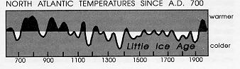
At Greenland's southern tip, something is actually
green these days. Along the coastline, there are small trees:
occasional willows as high as a person and, in sheltered spots,
dwarf birches only half as high. These, and the mosses and
berries that cover the ground, probably gave the place its name
among the boat-borne visitors lacking our elevated perspective
on the ice. Thus the name "Greenland" commemorates a
green facade, shielding the mountain of ice further inland.
And a fickle facade at that, varying from century to century
with the erratic climate of the North Atlantic.
THE CLOUDS WE ENCOUNTERED over central
Greenland now part and I see land below that isn't Greenland
because there are no glaciers -- it looks scraped clean, the
same kind of reddish Canadian Shield as Greenland, but I
think it hasn't seen a glacier for many millennia. If this is
Canada, then I missed seeing Thule, Greenland, known to the
rest of the world mostly for its cold-war radar installations
(and as the American "Siberia" to which unpopular Air Force
officers were reassigned). Canada's Baffin Island is north of
Hudson's Bay, and that must be it below. There is a lot of ice,
but exposed sea lanes as well, with pancakes of ice scattered
here and there -- not icebergs, just flat ice. The Inuit live up
here too, the last of the ice-age hunters; indeed, there are more
groups in the eastern Canadian Arctic than elsewhere. They
can be found from Siberia around to Greenland, following the
seals and bears.
Now if this were 1831, the year that the North
Magnetic Pole was first located on the Boothia Peninsula, we'd
be flying right over it. But it has moved since then, and is
now about 1000 kilometers (about 600 miles) out the right
window to the northwest. The North Magnetic Pole is the
point toward which all those decelerating charged particles
from the solar wind converge to cause the aurora borealis;
from space, the aurora looks like a fountain, spewing light --
making the Magnetic pole look considerably more exciting
than the Geographical North Pole. No northern lights for us
today; they're there 24 hours a day, but it's still noon and we
can't see them for all the sunlight that reflects off the thin air
to produce a blue sky. We missed the North Pole itself by
quite a bit, the distance between Miami and New York City.
So this over-the-pole flight might be better described as the
almost-over-the-magnetic-pole flight.
If this were 14,000 years ago instead, and I looked out
the left window to the south, I would have seen a "mountain
range" going all the way to New York City and Cape Cod.
The Laurentide ice sheet was truly massive, and so tall that it
probably deflected some of the jet stream to more northerly
latitudes.
What are Arctic travelers likely to see out the window
a few decades from now? Looking into the future with
computer simulations, this tundra beneath us may thaw in a
big way: northern Canada is likely to warm up more than
anywhere else on earth, as the greenhouse warming progresses.
The methane that the thaw releases from the tundra is also
likely to make the greenhouse even worse.
LAKES SEEM TO BE EVERYWHERE in the Northwest
Territories, and we've just passed near Great Slave Lake and
our first town since leaving Norway, Yellowknife. Far to the
right side must be Great Bear Lake, noted for an ancient
volcano tipped on its side, erosion exposing the internal
plumbing.
The natives that live up here were also quite
successful as emigrants to the United States; the languages
spoken by the Apache and Navajo, down south near the Grand
Canyon, are closely related to the ones spoken up here, and it
appears that the Athabascan-speaking peoples (named for a
lake off to our left) hunted and gathered their way down south
rather recently -- they barely got there in time to be used as
slave labor by the sixteenth-century Spanish in building their
churches in the Rio Grande valley. This was, of course, a half
century before the Pilgrims arrived in New England in 1620,
another fact that my school textbooks somehow omitted.
We've haven't seen much of the precambrian rock
protruding through the tundra, but hereabouts ought to be the
end of the Canadian Shield. Southwest of here is more recent
geology, late-arriving chunks of North America that sailed
across the Pacific Ocean during the last 50 million years.
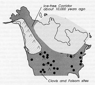
THE ICE-FREE CORRIDOR (minus the ice) is seen out
the right side, as the Rockies come into view. The pioneers
might have been able to walk across the Bering Strait from
Asia, but Alaska's northern interior was the end of the line.
The rugged coastline, augmented by ice sheets on the
continental shelf, probably prevented animals (including
humans) from moving south, though there might have been a
few small "harbors" along the way if boats were available.
And the great ice cap sitting atop Canada would have blocked
the alternative inland route. But it was a two-part ice sheet,
which is why a corridor was possible.
The Laurentide ice sheet didn't grow down from the
Rocky Mountains towards the east -- it spread west from
Hudson's Bay (drained empty by the fall in sea level) and
actually started to push up into the foothills of the Rockies
before it met up with the Cordilleran glaciers flowing down
the Rockies (eastern Canada then received much more snowfall
because the Gulf Stream shifted). From about 30,000 years
ago until 14,000 years ago, the two ice masses pushed against
each other; then between 14,000 and 12,000 years ago, as both
started to melt back somewhat, a corridor opened up from the
north coast of Alaska leading down to eastern Montana.
As I said, I tend to imagine this as something like the
biblical parting of the Red Sea -- a north-south corridor
opening up as the ice walls pull back on both the east and
west sides. Shortly after the corridor opened, there was a
human population explosion in the Americas south of Canada.
Besides the relatives of the elephant, there were lions, horses,
and camels in North America, back in those days. Many of
those species now remain only in Africa; Teddy Roosevelt,
early in the century, took a train trip through Africa and called
it a "railroad through the Pleistocene," a tour of what America
used to be like.
The corridor ran up the eastern front of the Rockies
from the southern limit of the glaciers, at about the Alberta-Montana border,
to Dawson Creek and Fort Nelson. We must
be over Dawson Creek, as I can now see the Alaskan Highway
snaking off to the west en route to Whitehorse and eventually
Fairbanks. The mountains continue northwest as the
Mackenzie Mountains all of the way up to the Yukon. No
glaciers visible now; just the unfurrowed white patches that are
permanent snowfields -- the seeds of glaciers.
So the earliest route to the south required first going
north, up above the Arctic Circle, almost (unless the Yukon's
valley opened up early) all the way up to the North Slope and
the Arctic Ocean coastline, reaching the Mackenzie River delta
and then turning southeast and traveling down the eastern front
of the Mackenzies and Rockies. There were a lot of lakes
along the way, formed by moraines of the Laurentide ice
sheet: the bulldozing ice snouts actually dammed up some
valleys of the Rockies in a manner not unlike modern
reservoirs, with an earthen dam of rubble stretched across the
exit to the valley -- except that the rubble was pushed
up the valley from below by that monster glacier from
Hudson's Bay far to the east. Herds of grazing animals
probably worked their way down the corridor, following the
new grasslands, followed by the hunters.
THE FIRST AMERICAN POPULATION explosion likely
came from those hunting bands that found their way down the
ice-free corridor. Or maybe it was the second or third, since
there is a lot of argument over whether there were some
human inhabitants in both North and South America during the
last quarter of the last ice age, more than 31,000 years ago.
Like the Vikings who explored the Atlantic coastline centuries
before the southern European explorers came and stayed (and
attracted the even later but more prolific English), so the
earliest human occupation of the Americas may have been a
multistep affair.
Because the corridor east of the Rockies was open
before 30,000 years ago, an earlier Bering Strait emigration
from Asia could, conceivably, have initially populated the rest
of the Americas. But the door closed on the corridor at 30,000
years ago, and didn't reopen until about the time of the Clovis
hunters, 11,800 years ago. Of course, the early South
American populations presently dated (these numbers are
forever being updated, and the radiocarbon dates recalibrated)
earlier than 31,000 years might also have arrived by boat from
the Pacific islands. Everyone is eagerly awaiting enough
bones and cultural artefacts from the early sites to make
comparisons to ancient populations of the Asian mainlands that
spread into the Pacific islands.
The present-day natives of North and South America
seem fairly closely related, just what one might expect from a
population explosion based on some initially successful
hunting tribes pouring through the ice-free corridor. Whether
or not some humans arrived even earlier, the hunters seen
starting at about 11,800 years ago were prolific big-game
hunters and left their Clovis-style arrowheads and spear points
all over the continent, including in the rib cages of some now-extinct
species of megafauna. Some groups certainly came
later, such as the Arctic-specialized Aleut and the Inuit perhaps
8,000 years ago.
There was, of course, a population contraction in more
recent centuries, as the native populations were decimated by
the diseases imported via the European and African
immigrants. That sort of replacement of one hominid
population by another is likely how modern-type Homo
sapiens, the descendants of the African "Eve" collection of
mitochondrial DNA that was around 150,000 years ago, came
to dominate the scene. They need not have brutally eliminated
Homo erectus and "archaic Homo sapiens",
though there probably were incidents of that sort, just as
occurred involving the U.S. Cavalry in the nineteenth century,
massacring Cheyenne Indian families at Sand Creek. It would
suffice to possess an immune system that could cope with a
virulent virus that predecessor immune systems could not.
It is difficult, as Richard Leakey points out, to
otherwise account for the widespread disappearance of the
predecessors (conquest, despite occasional massacres, tends to
lead to interbreeding and thus regional retention of some
characteristic features). Even without superior technology, the
Europeans could have displaced the American Indians -- just
with the smallpox that Europeans could survive better than the
Indians. Anthropologists often argue that waves of settlement
shouldn't occur without the newcomers having some advantage
such as new-model body styles or advanced culture -- but they
sometimes forget the pathogens and antibodies that aren't
preserved as well as stones and bones.
THE ROCKY MOUNTAINS take a brief respite and we
see interior valleys for a few minutes until we cross the Fraser
River and we're into the coastal mountains, looking every bit
as rugged as the Rockies. I can see why it would be hard to
walk down the coast from Alaska: the mountains continue to
the coastline; further north along the Gulf of Alaska, glaciers
extend right out to the water's edge, contributing more
meltwater to the oceans than any other glaciers in the world,
outside Greenland and Antarctica. But then we suddenly pop
out of the mountains and are over a real metropolis, complete
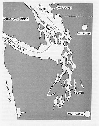
with a large river delta. It's Vancouver, British Columbia, and
that is the Fraser River emptying into the Strait of Georgia.
We are flying right down the strait between the
mainland and Vancouver Island to the west. I know we just
passed into United States airspace because we are over the San
Juan Islands, one of my favorite places; I spotted the Friday
Harbor Labs (at least its dock; the buildings blend so well with
the natural setting that I can't distinguish them). To the west
I can see the Strait of Juan de Fuca, separating Vancouver
Island from the Olympic Peninsula, and opening out into the
vast Pacific Ocean. The Atlantic for lunch, the Pacific for
dinner.
To the south is Puget Sound, not a sound at all (since
it is deadend) but rather a very long bay with only the one
narrow exit to the ocean. The world's larger "bays" include
the Mediterranean Sea and the Red Sea. They all have an
interesting salt economy -- not of the kind associated with the
camel caravans of centuries past, but a salt economy associated
with the bay's gains and losses of fresh water. The Red Sea
is an extreme example: it loses quite a lot of fresh water by
evaporation, but gains essentially none from rivers (or melting
icebergs!). It doesn't dry up into salt flats because less salty
Indian Ocean water is attracted in through the Strait of Bab al
Mandab -- and so the Red Sea's salinity has stabilized at about
ten percent higher than the oceans. Puget Sound has lots of
rivers coming down from the mountains to the east, south, and
west; no danger of Red-Sea-style hypersalinity here. Except,
perhaps, if it really turned cold and the winter snows turned
into glaciers rather than runoff.
The Mediterranean gets fresh water from some big
rivers such as the Nile and Rhone, but it also has quite a lot of
surface area for evaporating fresh water. As the Mediterranean
starts to get hypersaline, it attracts ocean water of normal
salinity in through the Strait of Gibraltar. This creates an
interesting circulation pattern. Hypersaline water is heavy, and
so it sinks to the bottom of the eastern Mediterranean, the
fresher waters from the rivers and the normal salinity seawater
from Gibraltar replacing it on the surface. The deep salty
water tends to escape, creeping along the bottom and out into
the Atlantic, just as the extra salt flushes out of the bottom of
the Red Sea into the Indian Ocean.
During the pluvial period about 8,000 years ago when
the greatly augmented monsoons were watering Africa and
turning the Sahara green, a lot more fresh water was delivered
to the Mediterranean via the Nile (and some large North
African rivers that can no longer be seen, their dry beds filled
in with sand). And the Mediterranean's salty circulation
pattern became the exact reverse (rather like Puget Sound
today): the fresher water stayed on the surface and flowed out
to sea, and some deep salty water was attracted into the
bottom of the Strait of Gibraltar. So while it is a salt
economy, it's really all a matter of fresh water runoff into, and
evaporation from, a basin.
While bays illustrate the principles more readily, the
same principles apply to regions of the oceans too, should you
have areas (such as the Northern Atlantic) with more fresh
water loss than gain. This principle was recognized several
centuries ago:
But if the water of the ocean, which, on being
deprived of a great part of its Heat by cold winds
[evaporation], descends to the bottom of the sea,
cannot be warmed where it descends, as its
specific gravity [density] is greater than that of
water at the same depth in warmer latitudes, it
will immediately begin to spread on the bottom of
the sea, and to flow towards the equator, and this
must necessarily produce a current at the surface
in an opposite direction.
Benjamin Thompson (Count Rumford), 1800
Just imagine the North Atlantic Current as the equivalent
of that normal salinity surface current flowing into the
Mediterranean at Gibraltar, nice and warm. To balance it, you
get a deep salty current heading south from Iceland; actually,
it flows from North Atlantic to the tip of Africa, east through
the Indian Ocean, around Australia and up into the North
Pacific.
It's a somewhat exaggerated version of the
Mediterranean's story: the water sinks like a stone around
Iceland because it is already hypersaline when it arrives:
Every winter at about the latitude of Iceland,
water of relatively high salinity, flowing
northward at intermediate depths (perhaps 800
meters), rises as winds sweep the surface waters
aside. Exposed to the chill air, the water releases
heat, cooling from perhaps 10 degrees C. to two
degrees [50° to 36°F]. The water's
high salinity together with the drop in temperature
makes it unusually dense, and it sinks again, this
time all the way to the ocean bottom. The
formation of the North Atlantic deep water, as it
is called, gives off a staggering amount of heat.
Equal to about 30 percent of the yearly direct
input of solar energy to the surface of the northern
Atlantic, this bonus accounts for the surprisingly
mild winters of Western Europe. (The warming
is often mistakenly ascribed to the Gulf Stream,
which ends well to the south).... [During the ice
age, the conveyor was shut down but resumed
during the melting; during the Younger Dryas],
the conveyor had shut down once again. Deep-water formation had stopped, and so the warm
intermediate-depth water that supplies Europe's
bonus of heat could no longer flow northward.
The chill over this region was dispelled only when
the conveyor began running again 1,000 years
later.... [One theory for the stoppage is that
meltwater] poured into the North Atlantic close to
the site of deep-water formation. There it reduced
the salinity of surface waters (and hence their
density) by so much that, in spite of severe winter
cooling, they could not sink into the abyss.
Wallace S. Broecker and George H. Denton, 1990
Cause-and-effect reasoning can be tricky because
nonlinear systems often chase their tails. This is a particularly
apt description of the North Atlantic Current: it even does a
vertical U-turn. The Current -- now so cold and hypersaline
that it is denser than any layer of underlying water -- plunges
from the surface to the abyss. There may not be a giant North
Atlantic whirlpool or waterfall to gaze down upon, but this
"deep water production" is equal in magnitude to 20 times the
combined flow of all the rivers of the world. Once the dense
water has sunk under its own weight to the sea floor, it flows
south -- and so attracts even more warm currents north to
replace it.
Why did this Current falter? On the model of the
Mediterranean in the last Pluvial, the obvious candidates would
be all those analogies to the augmented Nile: the salt-free
icebergs calving off of Greenland, that fresh water coming out
of the St. Lawrence River from eastern Canada's massive ice
sheet, and the meltwater from the Scandinavian ice sheet
emerging from the Baltic and from Norwegian fjords. The
North Atlantic got fresh water from all sides except the south.
With sufficient dilution of the ocean surface waters, there
wouldn't have been an "attraction" of warm tropical waters
northward to replace the hypersaline water that otherwise sinks
around Iceland. There may not be any major sources of
meltwater left in Canada or Scandinavia, but Greenland has
enormous supplies -- and its east coast fjords are located close
to the current focus of deep water production, south of Iceland.
A greenhouse-encouraged glacial surge into the fjords, or the
sudden emptying of a meltwater lake, might have effects on
climate far out of proportion to their effects on rising sea level.
And remember the "White Earth Catastrophe", where
the ice cover prevented rewarming? It could well have
happened to the North Atlantic in another sense. As wind and
evaporation are essential to the deep water production, ice
cover would limit evaporation and deep-water formation. An
iceberg deluge might have shut off the northerly movement of
(warm) replacement water, but also (by raising the freezing
point of the sea water) allowed winter ice to form much farther
south. Indeed, the southern border of the sea-ice islands
floating in the wintertime Atlantic descended from
Scandinavian to Iberian latitudes (55°N to 35°N)
as the Dryas started. This wintertime "cap" on the North
Atlantic would have delayed the resumption of the salt
conveyor. Ice matters.
WE ARE HEADING SOUTH into the Sound-that-isn't. I
just heard someone use the correct French pronunciation of
"Puget" -- but she was quickly corrected by another European
who explained that Americans make it rhyme with "fidget" for
some obscure reason. I hope that she hasn't heard about how
they pronounce Goethe Street in Chicago.
The Strait of Georgia and Puget Sound were also
emptied out by the drop in sea level during an ice age, making
this a possible path for a glacier. We are flying right down
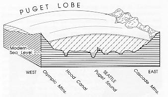
the route of the glacier that sat atop this area 15,000 years ago,
the southernmost "Puget Lobe" of the Coastal-plus-Rockies ice
sheet known as the Cordilleran. Icebergs set sail out of the
Strait of Juan de Fuca back then, just as they do now in the
Denmark Strait east of Greenland. The San Juan Islands were
scraped down to 350-million-year-old bedrock. The glacier
was a mile high (1,600 meters) here, half the height of Mount
Baker, the local volcano over to the east.
The massive tongue plowed down to the south end of
Puget Sound, backed up, advanced again, and generally
rearranged the land. Whidbey Island, which I see stretched out
on the left, is all glacial, sediments deposited by one glacier or
another, and carved by the silt-laden runoff from the last
meltback. I once encountered some brick fragments on the
beach at Double Bluff, near the south end of Whidbey, and
thought that they were surely of recent human origins, just as
are the plastics that have drifted ashore. But no, the geologists
tell me: the warm times of the last interglacial, 120,000 years
ago, produced a peat bog resting atop an older layer of clay.
And the peat bog dried up and caught on fire, perhaps due to
lightning, and so baked the clay beneath it! As it erodes out
of the cliff, the beach becomes littered with red brick
fragments.
All the north-south valleys in the Seattle area are
probably drainage channels that formed beneath the Puget
Lobe. We even got our own fjord out of the deal, Hood Canal
snaking along in its fishhook shape out the right window
(unlike the Norwegian fjords carved into hard rock, it looks
like a runoff channel from the lobe melting).
Below on our left, atop another glacier-shaped
landform, is Paine Field, the birthplace of our airplane --
together with all the other Boeing 747s in the world. Some
glacial landforms, such as Long Island and Cape Cod, are
rather like ancient landfills, plowed into place by the snout of
a glacier that then retreated. Actually, those Whidbey Island
bluffs were underwater during the meltback; their tops are the
sediments that accumulated in the lakes that formed south of
the retreating glacier about 13,000 years ago. The land had
been sinking slowly under the weight of the ice, but slowly
rebounded over the next few thousand years. And so now
these postglacial sediments are above sea level; though sea
level has risen during the interglacial, these rebounding
sediments have risen even more. This did not happen in
southern Puget Sound, as it was covered too briefly by glaciers
to sink very much. North of Seattle, the rebound has been
more than the sea level rise.
The rapid melting about 13,000 years ago left even
more dramatic evidence in eastern Washington state: a large
lake of meltwater formed east of the Idaho-Montana border,
but was held in place only by a dam of ice. When that dam
broke, the lake emptied suddenly, a great flood sweeping
westward. It carved a broad swath across the state until
channeled down the Columbia River along the Washington-Oregon border.
It sculpted deep valleys in a matter of days.
Similar events must have happened as the eastern Canadian
and Greenland ice sheets melted, so that the North Atlantic
was episodically flooded with fresh water, disrupting the
formation of the deep salty current that had attracted the warm
North Atlantic Current northward (and promoting winter ice
that "capped" the evaporation needed for resumption of the salt
cycle).
Climate change isn't always gradual, and reversals in
such salty streams may be among the reasons; still, my
physiologist's training makes me worry about the more subtle
reasons. All of this salt exchange reminds me of the early
days of our physiological understanding of the kidney (the
major player in another salt economy, that of our bodies).
Since then, we've discovered some of the more subtle
regulation, learned how to influence it (and high blood
pressure) with medications such as diuretics. Meltwater
deluges and ice-capping the salt conveyor may only be part of
the story, the equivalent of binge and hangover in the body's
salt economy (alcohol dehydrates the body unless a lot of
alcohol-free water is also consumed at the same time).
SEATTLE IS OUT THE LEFT WINDOW and I can
almost see home. Certainly I can see, in profile, that glacial
relic south of the University of Washington known as Capitol
Hill. The "Capitol Hill that isn't" was so named a century ago,
in hopes of getting the state legislature to locate the
Washington state capital there, but Olympia won. I look for
its tallest point (about 35 stories uphill from the university)
and a towering redwood tree with a perfect conical shape; my
favorite "park bench" is just below the redwood. They are in
a cemetery not far from home, a place where I often go
walking while thinking out some problem.
This white granite bench, you come to realize, is
actually a tombstone. Indeed, the most useful of tombstones,
inviting the visitor by its very placement to pause for a while.
Even on a typical Seattle day, you can see both Puget Sound
to the west and Lake Washington to the east. When the
clouds part, you see beyond the waters to the Olympic
Mountains and the Cascade Mountains, which together formed
a north-south channel for the Puget Lobe. On a clear winter
day after the leaves have fallen, the bench has a horizon-to-horizon
panoramic view, blocked only by that magnificent
redwood just south of it.
Deeply chiseled into the edges of the top slab of this
bench is a characteristically Seattle epitaph. As you walk
around the bench, it reads:
West face: West lies the Sound, South a great
tree
North face: North is the University
East face: East the mighty Cascades run free
South face: All these places were loved by
me.
And this unusual tombstone also offers no name, no dates
-- just an evocative reply to "What shall I build or write /
Against the fall of night?"
MOUNT RAINIER now appears majestic in the southern
sky as the plane banks over Tacoma to turn back north. This
massive white volcano stands about four times as high as the
Puget Lobe reached in Seattle (at 1,100 meters thickness in
Seattle, the glacier would have covered a building 260 stories
tall). The lowlands south of Tacoma and Olympia are where
the glacier stopped 14,000 years ago, though on earlier
advances it had gone slightly further before backing up. One
can see the deep valleys extending radially outwards from
Mount Rainier, like spokes from a wheel, carved by Rainier's
glaciers before they withdrew. Here and there, the radial
valleys meet the north-south valleys (some filled with long
lakes such as Lake Washington on Seattle's eastern border)
formed by the Puget Lobe.
Not only couldn't anyone make this over-the-pole
journey a few decades ago, but it's only in the last century-and-a-half
that we've even known the ice ages existed. And
the Ice Age still lives here, with nearly a thousand glaciers in
this state alone: about 40 glaciers cover Mount Rainier,
though some have receded as much as a kilometer in the last
century.
The Seattle-Tacoma International Airport is atop still
another assortment of glacial till; it's about as tall as Capitol
Hill but has been reshaped to look like a mesa. In the process,
they uncovered the skeleton of a giant ground sloth, common
in the area during the ice ages. Thomas Jefferson was the one
who discovered this species of sloth two centuries ago
(scientific literacy among American politicians used to be
somewhat better than it is today).
The airport runways now extend to the very edges of
the flattened hilltop. And so after the gradual descent on our
final approach, the ground suddenly seems to rise up to meet
us, like a slow kiss which accelerates.
It is about noon here, the end of a timeless journey
spanning the ice ages.
Deeds need time,
even after they are done,
to be seen and heard.
Friedrich Nietzsche

 The Ascent of Mind
(Bantam 1990) is my book on the
ice ages and how human intelligence evolved; the
"throwing theory" is one aspect.
The Ascent of Mind
(Bantam 1990) is my book on the
ice ages and how human intelligence evolved; the
"throwing theory" is one aspect. 