 |
A book by William H. Calvin UNIVERSITY OF WASHINGTON SEATTLE, WASHINGTON 98195-1800 USA |
|
How the Shaman Stole the Moon Copyright ©1991 by William H. Calvin. You may download this for personal reading but may not redistribute or archive without permission (exception: teachers should feel free to print out a chapter and photocopy it for students). |
|
Cornering the Sun in a Canyon
An idea about an idea - that’s what I seem to be following around the ruins. Or, at least, a hunch. Civilizations are built on ideas, and to understand ourselves, we need a better notion about how hunter-gatherers got the idea of giving up their wandering life style and settling down to agriculture and occupational specialties. That’s what the Anasazi did, starting several thousand years ago. My hunch seems, on the face of it, to be about such matters as what the Anasazi’s part-time architects considered "a good view" or a dramatic setting. Or what their priests might have found worth celebrating, such as a solstice. But if I can somehow connect such things to eclipses, there is the prospect of explaining how the local shaman evolved into the emperor’s astronomer, how priest-run protoscience bootstrapped itself up into science. Connecting the two heavenly ideas — solstice sightlines and eclipse forecasting — isn’t obvious, or I’d be reading about this in an old book rather than running around looking puzzled. More facts often help generate more ideas, so I continued to examine the ancient Anasazi sites on the Colorado Plateau to get some inspiration from the ancient architects, to visit the Pueblos to get some ideas from the Anasazi’s descendants. |
|
CANYON VIEWS AND MESA-TOP VIEWS are very different. Canyons, with their elevated
horizons all around, provide lots of notches to index the seasonal movements of the sun, enabling
the Indians to create a seasonal calendar for planting and ceremonies. The mesa tops favored by
most of the remaining pueblos instead offer long views, like those at Stonehenge. Was the
Anasazi’s attraction to mesa tops a defensive strategy like Herod’s at Masada, or is
it also wrapped up in their cosmology? At Chaco Canyon in northwestern New Mexico, one sees
a collection of Anasazi "towns" that link mesa and canyon.
Archaeologists, contemplating what has been found at Chaco during the last century, speculate that it might have been used only as a ceremonial center. Very few burials have been found. Estimates of Chaco’s population, based on the number of rooms and assuming the usual mortality rates, suggest that either a lot of burials are missing or Chaco was more like a modern-day resort town, with lots of rooms for seasonal visitors that are healthy enough to travel, but with few people living there year-round (and so a small cemetery). I somehow doubt that Chaco was a summer resort: cornfields needed tending during the warm months, and irrigation water needed to be delivered to the fields. But visits near the time of the winter solstice would not interfere with farming. Perhaps each visiting family helped to build a room onto 800-room Pueblo Bonito (another puzzle is that only several of the rooms show any sign of habitation via debris embedded in the floor). Chaco is located about a hundred kilometers south of Mesa Verde, and some of Chaco’s major roads lead north. But Chaco’s prime was centuries before Mesa Verde’s: its period of major construction was from about A.D. 900 until 1120. A few later structures were built in the Mesa Verde masonry style, so Chaco may have become an outpost of the Mesa Verde culture in the several centuries after the Chaco culture itself declined. Yet Chaco’s best centuries are among the most interesting, as the great expansion of Anasazi sites occurs about 1050 to 1100. In terms of widespread numbers and fancy architecture, the 900-1120 period may represent the height of the Anasazi culture, with Mesa Verde and Betatakin belonging to a later period just before the big decline. Chaco is not a canyon of cliff-dwellings, as there are few natural alcoves in its cliffy walls. While there are indeed a few cliff-dwellings, most of the ruins are situated out on the main floor of the canyon, separated somewhat from the cliffs in a manner quite unlike the more familiar Anasazi sites. |
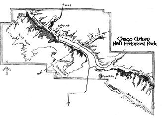 Chaco Canyon is a long, wide, and not particularly deep canyon that wanders along for more than
20 kilometers of the high plateau in northwest New Mexico. Dozens of Anasazi sites lie along
the length of this canyon and its surrounding mesa tops. Chaco has the most elaborate set of
Anasazi ruins that remain anywhere. They exhibit the fanciest architecture, the finest masonry
style, and the most elaborate road system.
Chaco Canyon is a long, wide, and not particularly deep canyon that wanders along for more than
20 kilometers of the high plateau in northwest New Mexico. Dozens of Anasazi sites lie along
the length of this canyon and its surrounding mesa tops. Chaco has the most elaborate set of
Anasazi ruins that remain anywhere. They exhibit the fanciest architecture, the finest masonry
style, and the most elaborate road system.|
CHACO DID NOT SEEM like a good place for studying the views from cliff-dwelling alcoves,
but it has a lot of kivas, including some huge "Great Kivas" that antedate many of the small kivas
that one sees at Chaco and elsewhere. So I eventually got around to visiting Chaco — and
at the winter solstice. A picture of a sunrise in the right place is worth far more than any set of
calculations based on magnetic compass readings. "All roads lead to Chaco" might have been an Anasazi slogan, though the modern driver cursing the heavily rutted dirt roads might have other thoughts in mind after several hours of approaching Chaco Culture National Historical Park. I doubt that the Anasazi’s roads ever became rutted and washboarded because the prehistoric Indians had no wheeled vehicles. No horses, either. So whatever did they need roads for? I have an anthropologist friend, Astrida Blukis Onat, who thinks that the answer to the road puzzle is foot races, the barefooted runners having some incentive to clear a racecourse. Long before marathon madness swept the western world, foot races were popular among Indians of the Southwest. An annual race from Taos Pueblo to Grand Canyon, nearly 800 kilometers (500 miles), has been run in recent years. Walking around Pueblo Alto on the top of North Mesa, I had some difficulty in seeing the ancient road from Mesa Verde. But the multispectral scanning techniques that supplement aerial photographs have shown a wide network of roads, all converging on Chaco. On the ground, the best way to spot an ancient road is to look for a suspiciously straight swath of sagebrush; the old roadbed probably channels rainwater, and so the plants grow better. And if you think that modern road-builders have a passion for building straight roads that ignore natural obstacles, just go look and see what happened to the road south from Mesa Verde to Chaco, once it ran out of mesa and reached the edge of Chaco Canyon. The Jackson Staircase is a series of steps carved into the sandstone cliff, wide enough for a procession to continue over the top of the cliff and down its steep face. No switchbacks. The Chaco builders started carving an even wider flight of steps nearby, but never finished the job. Stepping down the cliff face, I suppose, might have been the finish of a foot race — but it seems likely that their roads also had some ceremonial purpose, probably linked to their religious cosmology. |
|
EVENING WAS COMING at Chaco when I hiked back to the trailhead, but there was about a
half-hour to go before sunset. I drove down to the first major town, Hungo Pavi, and hiked
quickly out to its kiva. I watched the sun set over the opposite wall of Chaco Canyon, a totally undistinguished section of horizon. There was nothing even remotely cornerlike, no notches, no peaks except for a tree that probably was not there a millennium ago. So much, I thought, for Chaco — it’s going to be as bad as Mesa Verde. But in the southeast, a distant cliff rose up like a headland, forming a distinct step from the distant canyon floor. My compass suggested that the top of that cliff was on the sun’s path — might it, I wondered, function in the manner of that sunrise step at Perfect Kiva? Standing elsewhere in the ruined town didn’t seem anywhere as promising; the angles changed so that the cliff was no longer on the sun’s path through the sky. Tomorrow morning, I promised myself, I would be here with a camera rather than a compass, if only those clouds in the western sky did not move in and spoil things. |
|
THE MORNING of winter solstice, I awoke an hour before the time I’d calculated the sun
would rise over the top of that cliff. I drove up to Hungo Pavi with time to spare, and sat in the
car keeping warm until the sunrise hit the far walls of the canyon. Then I bundled up and headed
down the trail with my camera and little tape recorder. I was, of course, the only person
anywhere. What a way, I mused, to celebrate the winter solstice. I doubted that it was as quiet in
the pueblos. Clouds in the southeastern sky promised rain, but the sky behind my cliff was clear, to my considerable relief. I waited, looking at the top of that distant southeastern cliff for the first signs of the sunrise. But it seemed, judging from the brightening of the sky, as if my compass bearing had been wrong. The sun was going to rise minutes earlier than predicted — and from the bottom of the cliff, not its top! Something had been wrong with my compass, I realized (Chaco Canyon, I later noticed, has iron nodules embedded in the sandstone cliffs, causing magnetic reading errors of several degrees in many places). When the first gleam of the sun finally appeared, it was indeed in that bottom corner, where the vertical cliff edge intersected the horizontal stretch of distant horizon. It slowly rose to fill the frame: when its bottom touched the horizon, its left edge was touching the cliff wall. The sun had been "cornered," once again! As I had suspected, there wasn’t much choice in where to stand at Hungo Pavi; if I stood at any of the other major parts of the "town," the sun wouldn’t fit into the corner. The kiva was again in the right place. Back in the car with the heater running full blast again, I finished dictating my notes. Then I sat back and began to think about these special views that I was seeing from kivas: so far, they were always winter solstice views, either of sunrise or sunset, always with the sun framed in a corner, either formed by an alcove overhang or just a corner feature of a more distant cliff. It wasn’t positioning the sun behind a peak or a notch of some sort, the way that the known features of the Hopi’s horizon calendar functioned. Still, I had the chance problem to overcome, the one that had bothered me so much at Betatakin. While there was some consistency — the favored directions were always winter solstice — what I really needed to beat the percentages was a second solstice sightline that intersected in the same kiva. I needed more double plays, as in Anasazi Valley. It’s too bad that Hungo Pavi doesn’t have a winter solstice sunset view, I mused. I looked again at that featureless horizon to the southwest. I tried out the pocket transit and binoculars again, but there just wasn’t anything up there except some low trees. The canyon rim was as featureless and bland as the one seen from the Mesa Verde cliff dwellings. Perhaps I should hike up to the top of South Mesa and walk along that horizon one sees from the Hungo Pavi kiva? Try backsighting, just as I did at Mesa Verde, and find the right place for a cliff-edge shrine? |
|
THE TOPOGRAPHIC MAP was laid out on the hood of the car, its corners held down against
the wind by flashlights and cameras. I wanted to draw a line from the Hungo Pavi kiva to the
sunset on the winter solstice. Since the horizon was elevated about 3° as seen from the
kiva, my computer said that the right direction was 238°. I penciled in a straight line from
the kiva to the mesa at 238°. But I drew the line a little too long, continuing it back across
the top of the mesa. The line ran into something — a ruin up atop South Mesa, called Tsin Kletzin by the Navajo. It’s quite a way back from what looks to be the edge of the mesa top, but maybe.... Maybe the Sun Priest standing at Hungo Pavi’s kiva could have seen Tsin Kletzin in the old days, maybe it poked up into the skyline to form a marker for the winter sunset seen from Hungo Pavi. That might provide two intersecting sightlines at the kiva, and get me down to only a one-in-a-thousand chance of being fooled by a mere coincidence. I hiked up that trail to Tsin Kletzin a lot faster than my usual snail’s pace. Could I see Hungo Pavi from standing up at Tsin Kletzin? The topographic map said no, a near miss of less than about one-third of a degree, but maps have been wrong before. Seeing was believing. If I could see backward from Tsin Kletzin to Hungo Pavi, then surely the priest could see Tsin Kletzin from down below at the kiva, in the old days when Tsin Kletzin stuck up higher on the skyline. Once atop South Mesa, Tsin Kletzin stands in the distance, almost a mound in a flat field of scrub brush. As I walked toward it, I could see nothing of Chaco Canyon, only North Mesa which lay beyond the canyon. The disappearing canyon. Tsin Kletzin was set back far from the edge of the mesa, not close to anything, out in the middle of nowhere. It’s an enigmatic place, and not at all a site that had been used and reused. All of the trees used in its construction were cut in the three years starting in A.D. 1111 (known via the wonders of tree-ring dating), so it was a century or two younger than Hungo Pavi and most other ruins on the canyon floor. It was one of the last towns built before the droughts associated with Chaco’s decline. Tsin Kletzin is unusual in having several "tower kivas." They are not towering anymore, but the archaeologists can estimate their former height from the thickness of the walls, comparing them with the tower kivas which remain standing at other sites (such as Kin Klizhin, some miles south of Chaco proper). When the Anasazi built a four story masonry wall, they started with a thick wall at the base and made it thinner as it ascended. And the Tsin Kletzin kivas have thick foundations, suggesting a few stories height. When I climbed up atop the ruins of Tsin Kletzin, I could barely see the canyon walls of Chaco, descending into that distant groove in the landscape. Even at the highest point of the ruins, I could see only about half of the depth of Chaco Canyon. I certainly couldn’t see Hungo Pavi near the floor of the canyon. But what if the tower kiva were still standing, could I have seen Hungo Pavi from its top? That evening, after having watched the sun set over the mesa, I measured the elevations carefully from the topographic map and did a little trigonometry. The horizon elevation from Hungo Pavi should be 2.95°, very close to the 3.0° I’d measured with the pocket transit several times. How far would the tower kiva have to stick up to show above that horizon? If it (or a projecting "flagpole") rose several stories further than present (24 feet or 7 meters), it would form a excellent corner of skyline in which the sun would seem to set when viewed from the Hungo Pavi kiva. Furthermore, there were two tower kivas up there. As best I can tell from the archaeological map of the site, the second one would have stood alongside the first when viewed along that sightline from Hungo Pavi, rather like those Stonehenge stones framing a narrow sightline. The slot between the two tower kivas looks like good old 238° again, the sightline up from the Hungo Pavi kiva to winter solstice sunset. Had the Anasazi built a whole town, just to create a corner or a slot? Maybe. The direction from Hungo Pavi’s kiva is exactly the right one for marking the winter solstice sunset. But why hadn’t the Anasazi built Tsin Kletzin on the edge of the mesa, in plain view of Hungo Pavi? Why is it set back by 670 meters, so that an extra-tall tower kiva was needed to compensate? Could that middle-of-the-mesa spot be the intersection of two sightlines, so that the towers were doing double duty? I tried all of the known ruins in the area, to see if Tsin Kletzin was in a solstice or equinox direction from any of them. No luck, though it is possible that it would have been a summer solstice sunset view from some ruins farther down Chaco Canyon outside the park boundaries. Archaeologists prospecting for new ruins might want to look along solstice sightlines to and from Tsin Kletzin. The Tsin Kletzin towers in Hungo Pavi’s sunset might, of course, simply be a consequence of a town plan that favored cardinal directions for orienting structures. Washington, D.C., serves as an example: If you stand at the Capitol building, the Washington Monument is due west — and so at the equinoxes, the sun nestles into the corner that the spire forms with the horizon. That’s a consequence of the town plan’s fondness for cardinal directions. Another consequence are the curses of the rush-hour motorist near the equinoxes when sunset occurs directly at the end of an east-west street, framed by buildings on either side, the setting sun shining right in the motorist’s eyes. A town plan that avoided street orientations within of the sunset possibilities (about 240-300° at such latitudes) would circumvent that hazard, e.g., simply rotate the usual square street grid about 45° from the usual north-east-south-west. |
|
THINKING OF TOWER KIVAS as index features reminded me of the downstep at Perfect Kiva,
and of how one could pivot about it, maintaining a standard view from day to day, the
observer’s position becoming the measurement. Was a tower kiva at Tsin Kletzin situated
away from the edge of the cliff so that priests could walk around it in a circle, a good distance
away? This thought served to remind me of that side-stepping scheme for Perfect Kiva.
Of course, you do not need to build a tower kiva to get a corner — any cliff around here will do, at least for some of the year. Move around from day to day, keeping that standard view of the sun nestled between the horizon and the rising cliff face, looking like that Hungo Pavi solstice sunrise view. The advantage of a tower atop a flat mesa is that the same corner can be used all year, for both sunrise and sunset measurements. That offset of Tsin Kletzin from the canyon rim would have been handy for making sunset measurements on the days when sunrise was clouded. |
 To make the sidestepping method work atop a mesa with a tower kiva merely requires that you
adopt a standard criterion for the rising sun. For example, to keep the rising sun nestled into the
corner formed by the horizon and the tower, you will need to stand in a different place tomorrow
than you did today. Near the equinoxes, the sun’s position on the horizon changes by
more than a diameter from one day to the next; with a 600 meter radius, that means that the
observer would be as many as seven or eight paces away from the previous day’s
observing position. That’s hard to miss noticing. The differences would diminish as the
solstice neared, little sidesteps merging into a standstill lasting for days and days, then turning
around.
To make the sidestepping method work atop a mesa with a tower kiva merely requires that you
adopt a standard criterion for the rising sun. For example, to keep the rising sun nestled into the
corner formed by the horizon and the tower, you will need to stand in a different place tomorrow
than you did today. Near the equinoxes, the sun’s position on the horizon changes by
more than a diameter from one day to the next; with a 600 meter radius, that means that the
observer would be as many as seven or eight paces away from the previous day’s
observing position. That’s hard to miss noticing. The differences would diminish as the
solstice neared, little sidesteps merging into a standstill lasting for days and days, then turning
around.|
EQUINOX IS HALFWAY ALONG THE ARC between winter and summer solstice viewing
positions. But maybe the Anasazi didn’t think in terms of bisecting angles (which can be
simply done via stretching out a rope between the extreme positions and then folding it in half).
If they were counting consistently, you might suppose that they could count the days between
solstices and divide by two. But you would be wrong; because the earth speeds up in its orbit
when closer to the sun, the "quarter-years" are of unequal length, ranging from 91 to 94 days (91
days from winter solstice to spring equinox, which is why February has only 28 days). What
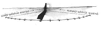
simpler way might they have had of locating the equinoxes? The Two Priests Method for warning of lunar eclipses can also be used to find the equinox day. No index is needed. Just stand out on the mesa top somewhere with a clear view of eastern and western horizons. We tend to speak of the equinoxes as when the days and nights are of equal length, patently an impossible determination before clocks. But the equinox is also when the sunrise and sunset lie along a straight line that includes the observer. At winter solstice in Chaco, the sun rises at 120° from due north and sets at 240°; that’s a 120° dogleg angle between them. At summer solstice, sunrise has moved northeast to 60°, the sunset to 300°, opening up that acute dogleg angle into a hyperextended oblique angle. Midway through the cycle, sunrise and sunset lie along a straight line from 90° to 270°. Given how much the angle changes from day to day near the midpoint of the cycle, you’re going to have one day when it’s almost 180° from sunrise to sunset, and the next day it will be a little more than 180°.
Did they actually do this? The Chaco Anasazi do seem to have known about the east-west line associated with the equinox. At Pueblo Alto, atop North Mesa where the road comes south from Mesa Verde, a long east-west wall extends through the entire town. And the great kiva, Casa Rinconada, has a perfect north-south axis (and there was no Pole Star back then) with niches along the east-west line. The eastern pueblos indeed use north-east-south-west as their cardinal directions today, but this may be due to European influence; certainly the Hopi and Zuni, the least influenced of all the pueblos, use solstice directions. You can’t use the Two Priests Method, for either equinox determination or eclipse warning, down in a canyon because the elevated horizons will interfere. But a few diameters of horizon elevation total (either in the east or the west, or some in each) won’t cause serious errors. Indeed, by offsetting the bending of light rays by the atmosphere, the slightly-elevated horizons will help the observers make the measurement near the true horizontal. The east and west views from Pueblo Alto total about 3-4 diameters of horizon elevation; if they used the first gleam of sunrise and the last gleam of sunset, they should have been able to determine the equinox to within a day of what modern techniques give. And the long uplands are not the only mesas that could be used; the truncated mountains such as Acoma’s mesa, or the peninsulas such as Cape Royal, would function nicely for equinox determination, especially if the criterion of the sun sitting atop the horizon were used. The equinox would make a good New Year’s Day, instead of the New Year’s Day we use, just ten days after the winter solstice. Because the sunrise or sunset position moves 0.6° every day in the spring and autumn, you can get a clear yes-or-no answer to the question: Has spring started yet? Nothing dramatic may happen to the sun on that particular day, but if you’re measuring, it is easy to tell before and after: the eastern observer sees the sunset move from one side of the western observer to the other, just from one day to the next. |
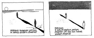 But how would an Anasazi have measured this straight line, given that the measurements have to
be separated in time by 12 hours? In the morning, the two priests play the initial part of their
game: A stands still at a spot marked on the ground and B moves around until the sunrise is just
behind A. He marks the spot. Just before sunset, the two priests return and take up the positions
they had marked on the ground that morning. It is now A’s turn to watch, without moving
off his marker, and see if the sunset occurs exactly behind B. The day before the equinox, sunset
will be just to one side of B. The next night, it will be immediately behind B or just a little to the
other side. That’s the equinox.
But how would an Anasazi have measured this straight line, given that the measurements have to
be separated in time by 12 hours? In the morning, the two priests play the initial part of their
game: A stands still at a spot marked on the ground and B moves around until the sunrise is just
behind A. He marks the spot. Just before sunset, the two priests return and take up the positions
they had marked on the ground that morning. It is now A’s turn to watch, without moving
off his marker, and see if the sunset occurs exactly behind B. The day before the equinox, sunset
will be just to one side of B. The next night, it will be immediately behind B or just a little to the
other side. That’s the equinox.
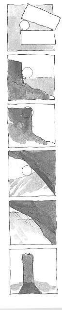 IT WAS BEGINNING to look as if the Anasazi liked their solstice sun to rise and set in corners
— so much so that they’d build a corner, if a natural one wasn’t in the right
place. And that they would use a variety of framing schemes. I felt that I was, at last, beginning
to see things the way that the Anasazi did back in the American stone ages. They liked to corner
the sun.
IT WAS BEGINNING to look as if the Anasazi liked their solstice sun to rise and set in corners
— so much so that they’d build a corner, if a natural one wasn’t in the right
place. And that they would use a variety of framing schemes. I felt that I was, at last, beginning
to see things the way that the Anasazi did back in the American stone ages. They liked to corner
the sun.The Mayan glyph for sunrise was indeed a circle sitting atop a stone, with another stone framing one side of the circle at an acute angle to the base. There are a number of variations on the sunrise glyph, but in all of them the "sun" looks as if trapped in a funnel. Thus it seems possible that cornering the sun was more widespread than just Anasazi. While Mayan influences are seen in Anasazi archaeology, they are relatively infrequent — at least, compared to what you see in the Anasazi’s contemporaries just to the south, the Sinagua (who had ball courts and other characteristically Mayan architecture). More than parrots made the trip north. So we are seeing a variety of cornering criteria at the various Anasazi sites:
I’m making progress — indeed, I have rediscovered some fine methods for detecting the equinox, and for keeping a day-by-day calendar throughout the year. But I still have no answers for the skeptic about Exhibit B (Of what use are solstice sightlines, if not for anchoring a calendar?) and Exhibit A (Why do we see artificial horizons that are elevated?). How do these observations all hang together? I was beginning to despair about connecting solstice sightlines to eclipse forecasting until I visited Canyon de Chelly. |