|
A book by William H. Calvin UNIVERSITY OF WASHINGTON SEATTLE, WASHINGTON 98195-1800 USA |
|
How the Shaman Stole the Moon Copyright ©1991 by William H. Calvin. You may download this for personal reading but may not redistribute or archive without permission (exception: teachers should feel free to print out a chapter and photocopy it for students). |
|
Sightlines to Somewhere
Camping out that night after the hike up out of Anasazi Valley, I discovered an interesting use for a north-facing alcove that we’d visited (where, alas, we had to rebury some human bones that were scattered by thieves in their search for Anasazi pots). You can use a north-facing overhang to point at the "axis of the universe." Naturally I thought of this use too late to check out that particular alcove. Particularly if it is really dark and there is a canyon rim to the east of you, the stars seem to pop out, one by one, in the dry desert air. While it is really the earth rotating, a flat-earth viewpoint might reasonably assume that the heavens were rotating. And there is one star that doesn’t move very much these days, not more than 1-2° during the night. Polaris seems to be the immobile point around which the heavens spin, the axis of the universe. There was a tall tree just north of where I camped, a dead tree that looked as if it had been struck by lightning in centuries past. I walked around on the mesa until Polaris stood atop the pinnacle of the tree. Now I had a pointer to the "Axis of the Universe." I went back to camp and got my sleeping bag, bringing it back to this spot, laying it out so that I faced the tree. Whenever I woke up that night, Polaris was still atop the tree (actually rotating in a tiny circle around it). But the other stars had shifted quite a lot, seemingly rotating around that tree top. The handle of the Little Dipper, Ursa minor, indicated the time, in effect. The "pointer stars" of the Big Dipper, Ursa major, are even easier to locate, drawing an imaginary pointer to Polaris. Both handles were like the hour hand of a clock. By comparing a handle’s angle relative to the tree with what the angle was at twilight, I could estimate what hour of the night it was. Do you suppose that’s where clock hands come from? (Shadows from sun dials are the usual candidate, but they don’t usually rotate in a complete circle as the stars do.) I thought back to that north-facing alcove - and wondered if it might have a notch in its overhang that would point to the same place in the sky, if you were to lay in the Right Spot. North-facing overhangs also might have summer-solstice sightlines in their corners and notches. Of course, the Right Spot wouldn’t have been Polaris back in Anasazi days, with Polaris rotating in a more noticeable circle (about 6 radius) about the Right Spot. I haven’t heard much about the archaeology of north-facing alcoves, except that they were used as burial places. An honored position for honored dead in the Right Spot? The Pueblo peoples do have strong traditions about an underworld that is six months in advance of the real world, which a life-afterlife summer-winter antithesis would fit right into. I think that, if I were an Anasazi trying to piece together a story of the universe, this might all seem to make perfect sense. Or am I just extrapolating too much? It took hours before I finally fell asleep. And then I woke up hours later (according to my handy clock), thinking about tepees, those conical tents of the plains Indians (and various tribes are known to practice star-watching from inside ceremonial tents). Tepee smokeholes ought to have a view of Polaris too, if you could lie on the floor in the right place. That almost caused me to get up and go pacing around. But I discovered the problem with that theory even before leaving the warm confines of the sleeping bag: the tepees couldn’t be tall and narrow unless they were at Canadian latitudes; the farther south you go, the broader the base of the tepee would need to be, if anyone was to see Polaris out of its smokehole. At Anasazi latitudes, the tepee would need a radius that was somewhat more than its height. A little squat - not the usual shape of a tepee. Another good idea, spoiled by trigonometry. But most north-facing overhangs in Anasazi Valley are probably deep enough so that an observer could see Polaris in a notch in the overhang.
|
|
MESA VERDE in southern Colorado has the most famous of Anasazi cliff dwellings (if I
discover that someone has never heard of the Anasazi, explaining that the Anasazi were the
people who built Mesa Verde always provides instant comprehension). I wondered whether the
Mesa Verde kivas had solstice sightlines, too. It was only a day’s drive to find out. Even from the map, the prospect of discovering solstice sightlines was discouraging because most Mesa Verde alcoves (Balcony House is the major exception) face west or southwest, not south in the manner of the cliff dwellings in Anasazi Valley. An observer back in an alcove that faces to the west would not see the winter sun until afternoon. Such alcoves certainly must have been cold in the winter (and they often got the hot afternoon sun in the summer, as some alcoves are not very deep). Chapin Mesa just doesn’t seem to have any deep natural alcoves facing south, at which to apply the architectural principles that the Anasazi clearly knew all about, judging from other cliff dwellings. Perhaps the Anasazi considered Mesa Verde a second-rate building site. So, I did not expect to see solstice sunrise alignments in a crescent corner. From back in the alcove, the sun rises in the afternoon, descending from the top of the overhang! Might a kiva at Mesa Verde, nonetheless, be situated for "a good view" of winter solstice sunset? But, at Mesa Verde, one cannot simply go and look (Write an application and wait a year while we consider it, insisted the head archaeologist). I decided to do a quick preliminary survey from the mesa tops to the west. (An important element of modern scientific strategy, surely not faced by prehistoric protoscientists, is, "Do preliminary observations before spending time at writing long applications.") Cliff Palace, the most famous restored pueblo, can be viewed from a tourist overlook that is on a finger of the mesa top just across a little valley to the southwest of the alcove. And, I realized, the inhabitants would have seen their sunsets right over where the tourist overlook now stands. If tourists a thousand years ago had stood there too, they might have blocked the view of the winter solstice sunset from those kivas inside the alcoves - just as Indians standing in the window at Delicate Arch could have turned the stage spotlight on and off. I didn’t need permission to wander around that finger of the mesa. And so I endeavored to find exactly the right place to stand, just to see if it corresponded to some notch in the cliff edge or ruin on the mesa top. Standing on the mesa rim, I had to look 5° down to the kivas in Cliff Palace, so that a shaman at a kiva ladder would have had to look 5° up to where I stood. The sun’s path through the southwest sky on the winter solstice passes through 5° elevation when at a bearing of about 236°. Facing northeast, I took back-bearings and promptly maneuvered myself to the exact spot on the mesa top where their winter solstice sunset would occur (so that the back end of my compass needle pointed to 236°), the spot on the rim that the sun would appear to touch, viewed from their kivas. And that place on the rim was unexceptional - it had no notch. There were no ruins nearby. There was no hole in the rock, no nothing. And not for any structure inside the alcove, kiva or not. Well, perhaps these people liked summer solstice sunsets instead, and so I tried the sightline at 296°. Nothing. Remembering the moonrise and moonset extremes at Stonehenge, I even tried them. Nothing again. I tried at Spruce House Ruin, but nothing there either. I couldn’t find a single half-promising sightline in my preliminary survey of all the cliff-dwellings on the usual tourist route around Mesa Verde. That quick survey saved me a week of paperwork and a second trip to southern Colorado. Maybe some ruin has a solstice sightline - the maps aren’t good enough to rule that out - and maybe some kiva had a mesa-top marker that did not endure. But within several hours, I convinced myself that the typical Anasazi kiva at Mesa Verde does not have a demarcated view of a solstice sunset (and certainly not of a solstice sunrise). Hmm. Are these ugly facts, or have I merely over-generalized?
|
|
BETATAKIN and another great alcove, Keet Seel, are located in Arizona within Navajo
National Monument, about 60 kilometers east of the Grand Canyon. They are far more
impressive in appearance than Mesa Verde. Navajo National Monument lies about 20 kilometers north of the tracks for the automated coal train that Edward Abbey described in The Monkey Wrench Gang. Betatakin is on a high forested plateau just east of the White Mesa; gullies cut down into it, just as at Anasazi Valley, but not quite as deeply. Still, it is perfect country for alcoves under overhangs. Betatakin is an alcove in which the Anasazi built a village starting in A.D. 1250. We know that from the trees they cut to build their roofs and ladders. They abandoned Betatakin in A.D. 1279, after only one generation. As the thirteenth century ended, so did the great cliff-dwelling phase of the Anasazi. The decline of Betatakin occurred about the same time as that of Mesa Verde - indeed, the distinctive Anasazi culture itself also dwindled away over the next half century. It is often said that the Anasazi people themselves disappeared and, while the population decline makes that somewhat true, it is really the distinct culture that ended then, in the merger with non-Anasazi tribes that led to the pueblo culture. A 29-year-long history provides the archaeologists at Betatakin with a brief snapshot in time; Old World archaeologists often have to contend with a series of occupations, their layers somewhat smeared together in time because someone reused materials from an earlier construction, or dug down into an older layer to bury something or create a foundation. But Anasazi archaeologists are used to such brief snapshots - a great many Anasazi sites were inhabited for less than a century, and never reused.
|
|
GOVERNMENT NAMES FOR ANASAZI SITES are usually wildly inaccurate. As a name,
Navajo National Monument has some minor logic: the Navajo may not have constructed the cliff
dwellings but the land was later a part of the Navajo Indian Reservation. An Anasazi site in
northwestern New Mexico is called Aztec National Monument, a truly gross misnomer as the
Aztecs were never anywhere near these latitudes. The first thing that the park rangers have to
explain at national monuments in the Southwest is that the names are wrong, a product of
anthropological ignorance back in the days before the land was set aside - and officially named -
by an Act of Congress. No major Anasazi site is officially named for the Anasazi - not even "Anasazi Valley." I’ve created a nom de guerre because of its fragile nature, though I haven’t changed the names of the ruins themselves which are clearly described in the archaeological literature. Most Anasazi sites are totally unprotected against looters, so archaeologists guard their maps. You can’t buy the good topographic maps at some national park visitor centers anymore. That policy may cut down on the casual hiker taking home something, but the professional looters have often been in the business for generations, father introducing son to backcountry sites, a collection of the best maps probably being a family heirloom. Since the Antiquities Act of 1979 made looting ruins a matter of federal law even when done on private land, there have been some notable prosecutions of thieves, some of whom held public office in Utah and had escaped state prosecution for years.
|
|
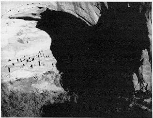
A HIKE DOWN THE PATH behind the Navajo National Monument’s visitor center brings one
to a view of Betatakin from the cliff top across the canyon from it: one’s first impression is that it
is enormous, a giant bandshell in an orange cliff, suitable for an orchestra of a thousand. Unlike
the cliff-dwellings at Mesa Verde, which almost fill the alcove, the building sites at Betatakin
occupy only the bottom fifth of the height of the alcove. There is no lack of headroom.
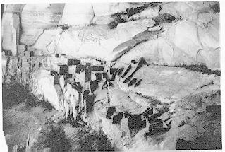
Betatakin has a steep, sloping floor and the foundations of the rooms are cemented onto this potentially slippery slope. An area in the middle of the ruins has slid away totally - and I don’t mean that the building slipped off its angled foundation, but that the underlying slab of rock itself has slid downhill. This erosional pattern - along with sections of the alcove’s roof collapsing occasionally - most likely created the bandshell. And so, because of the slope, Betatakin’s layout is nothing at all like the one permitted by Perfect Kiva’s flat floor. I took the first tour of the day, pocket transit in pocket, following the park ranger up the valley. Betatakin looks enormous as you approach it from below, every bit as impressive as the view from the high overlook across the valley. After exploring all of the ruins on the usual route and searching in vain for the characteristic kiva shape and ventilation shaft, I finally asked the ranger. Only the kiva’s foundations remain, he explained, just below the diagonal path that allows access to the east end’s upper stories. And so I picked my way carefully over to where he indicated, one of the steeper slopes and - one might think - not a very desirable building site for such an important structure. I sat down on the trail, probably the access route to the kiva ladder in the old days, and pulled out the pocket transit.
The southwest corner, where bandshell meets the distant horizon, is not anywhere close to winter solstice sunset. Nor is the southeast crescent corner near the winter sunrise: it is far too low to be on the sun’s path through the sky on the shortest day of the year. Had I struck out again? I noticed, however, an interesting ledge in the overhang, which forms a notch, and so I measured it too. It is at 139.5° from north and elevated 17.5°, very close indeed to the sun’s path on the winter solstice. So the rising sun would be framed by that notch - at least, if you stand at the kiva. Could the little step be a symbolic substitute for a crescent corner? Betatakin’s kiva makes a total of three kivas with a special view of winter solstice sunrise - special, at least, compared with other structures in their village. As I hiked out, I speculated: Mosques face toward Mecca, could kivas face the sun’s path through the sky on the winter solstice? (Well, except for those kivas built by the poor relatives at Mesa Verde.) I could see that I was going to have to collect some more kivas.
|
|
AFTER A COOL DRINK of water back at the visitor center, I was all set to continue on to Keet
Seel (Navajo National Monument’s other great alcove) as soon as possible, to see if its kiva was
also in the right place for a special solstice view. I looked at the archaeologists’ map of the Keet
Seel ruins and, to my dismay, there were dozens of kivas! This is a case of "too much of a good
thing." They can’t all have solstice views. Even if a few did, who would believe my kiva-siting
theory, when I had so many kivas to select among? I was immediately reminded of the cogent criticism of the sightlines of famous ruins in Egypt, Europe, and Central America, the ones that are supposedly oriented to point at a certain star. Because so many stars are packed into the night sky, any given sightline always points at one star or another. Unless one has strong independent evidence for a people favoring a particular star, saying that a sightline through an ancient ruin points to where Sirius rises is like saying that the view out my bedroom window was created to point to the rising of Sirius. Every sightline points somewhere and every few minutes, a different star moves into the sightline. Such stellar sightline claims are not very convincing to anyone who thinks in terms of modern control experiments, of the probability that a sightline could be thus-and-so merely by chance. Have I fallen into the same trap with kiva sightlines? While sipping coffee in the visitor center, I asked myself whether my Betatakin sightline from the kiva to the prominent notch in the overhang happened to point to the sun’s winter solstice path just by chance, that the Anasazi just happened to build the kiva there for some other reason but it turned out to have this nice view. The first uncertainty is that the sun has a finite size and I don’t know whether the Anasazi liked to sight using the top of the sun, or its left edge, or its right edge, or its bottom. So there is 0.5° uncertainty, just from that - a half degree of freedom to fit a square peg into a round hole, as it were. The sun’s size is not the only "loose fit" in this business. The second bit of slack is that there is a span of about 60° between the northeastern summer solstice sunrise (at 60° from north with a horizontal horizon) and the southeasterly winter solstice sunrise (at 120°). And as I move around within an alcove, the angles keep changing to the various horizon features. What, one must ask, are the chances of my finding a viewpoint at which a particular horizon feature in that general direction comes to lie between 60.0° and 60.5°? Or between 119.5° and 120.0°? You could fit 120 objects of the sun’s apparent diameter side-by-side into that sector, so the chance of the sun hitting any one 0.5° segment is 0.8 percent. That is the chance of a randomly selected sightline being usable for winter solstice. There is also a 0.8 percent chance of the sightline being used for summer solstice sunrise, since I’ll shout eureka if it hits either one of them. So the probabilities total 1.6 percent that I could pick an easterly feature by chance that would work for one or another of the solstice sunrises. Someone, I groaned, should do this analysis for Stonehenge and Avebury viewpoints too, all those dozens of stones to choose from, each with two sides. Now, suppose that there are two interesting horizon features along the eastern horizon from which to choose - as there are down at Betatakin: the usual crescent corner, and that prominent notch higher on the overhang (the one that seems to work pretty well for winter solstice sunrise). Having two candidates doubles my choices, doubles the risk that I’ll find something just by chance, rather than because the Anasazi liked to build their kivas where there’s a solstice view. Two convenient sightlines mean I’ve got a 3.2 percent chance of having one of them fit my summer-or-winter-solstice-sunrise hypothesis. And since I can pick and choose from the western sky in the same way, double that if there are two interesting features along the southwest-to-northwest horizon. We’re up to 6.4 percent. I don’t even want to think about bumpy skylines such as the Palisades of the Desert, with a dozen notches rather than two. Two candidates in the east, and two in the west, gives me one chance in sixteen that I’m fooling myself about Anasazi intentions, should I find a single solstice sightline from a particular viewpoint. Most scientists won’t accept chances that big as "significant," sufficiently different from the it’s-all-random alternative. Even a one in a hundred "chance level" can cause eyebrows to be raised. So single sightlines from single sites, by themselves, are not going to be persuasive. They offer too much "creative freedom," when what you want is to be constrained by the facts, to be forced to say, "That’s the only possible answer." My opinion of half the archaeoastronomy literature took a nosedive - so much of it could just be wishful thinking, a clever modern idea imposed on the site and tailored to fit. We want something as unequivocal as a suit of armor, but what we typically get in archaeoastronomy is a situation about as flexible as a bolt of stretch fabric, which fits anything. I cheered up after realizing that, while my pessimism may be appropriate for analyzing one site at a time, were we to survey many Anasazi kivas and they typically had winter solstice sunrise sightlines, then that would be pretty persuasive that solstice sunrise views were important kiva-siting considerations - a pattern is one way to get around the daunting odds posed by data from only one site.
|
|
ANOTHER WAY to escape the depressing probabilities would be to discover two solstice
sightlines intersecting at a kiva. The special viewpoints at both Split-Level Ruin and Perfect
Kiva were in about the right place for both sunrise and sunset at winter solstice. If you can pick the second sightline without being constrained by the first one, their individual probabilities multiply to give the probability of both happening by chance. With two candidate sightlines from the eastern horizon to choose between, and another two from the western, the chance of being in the right place by chance for two solstice sightlines is about 3.2 percent of 3.2 percent, or 0.1 percent chance of both happening randomly from the same viewpoint. And that one-in-a-thousand probability would apply to a winter-solstice sunrise and a summer-solstice sunset seen from a single viewpoint. The chances of both sunrise and sunset on the same solstice having sightlines through my viewpoint is even smaller. This makes sites with two same-solstice sightlines pretty rare by chance, and far more believable than a single sightline that fits one of the varied possibilities. That an intersection should also contain the Anasazi’s most unusual building type also improves believability.
|
|
ACOMA PUEBLO reminds me of nothing so much as King Herod’s mountain-top fortress
overlooking the Dead Sea. Both Acoma and Masada are solitary, flat-topped mountains - a
mesa, to use the Spanish word for table - and capped with buildings. Although it is fortified, Herod’s mesa is basically your standard Roman winter palace, the first century B.C. version of going south for the winter (Herodion, atop a breast-shaped hill south of Jerusalem and east of Bethlehem, is the summer version, up in the cooler Judean Hills with breezes from the Mediterranean). Masada is one of the best places in the world to see a Roman palace, for the simple reason that another town was never built atop it. Deserts have their virtues (less desirable sites, and a dry climate that preserves) and so archaeologists spend disproportionate amounts of their time at desert sites, dealing with hot dust. Acoma Pueblo is still inhabited. It has the same desert setting as Masada, though without the view up the northern extension of the East African Rift Valley that Herod had. The Rift is part of that super-fault-line that extends from South Africa to Turkey, and the reason why Jericho has four major earthquakes every century (which still cause its walls to come tumbling down). Acoma lacks the opulence of Masada, whose construction and ongoing water supply were supported by slave labor. Acoma’s problem was the reverse: the Spanish regularly hauled its young people away into slavery for all of that church construction that needed manual labor. But Acoma survived in its low-budget way, and stands today as a living monument to how determined native American hunter-gatherers can make a go of marginal farming in a country where the non-native Americans seemingly cannot live without importing gasoline, electricity, and water. Acoma is one of several pueblos that you encounter when driving west on the interstate highway from Albuquerque, New Mexico. Driving south from the freeway exit, the first sight is a tall mesa that appears uninhabited. It is sacred to the people of Acoma, the topic of many legends (I don’t know what their name for it is; their tourist brochure says that others call it "Enchanted Mesa"). It rises about thirty stories above a flat desert floor in the midst of a wide valley. I wondered if there were ceremonial sites atop it with solstice views, but the archaeologists seem not to have been successful in persuading the tribe to permit surveys; the tribe does not even permit hikers to visit.
To the south of Enchanted Mesa is another mesa, somewhat larger. Atop it are many buildings,
including the bell tower of a church (the San Esteban del Rey Mission was built in 1629-1640,
after Catholic missionaries followed the Spanish soldiers into the area). This is Acoma, first
inhabited back in early Anasazi times, nearly two thousand years ago, with an influx of people
from the Mesa Verde area about A.D. 1300. Coronado’s army visited it in 1540, describing it as
Like Masada, Acoma has a rocky path leading from base to top, which passed through easily guarded "choke points," as soldiers would say today. A twentieth-century addition has been a blacktop road; fortunately, tourists’ cars are not allowed up it. Tourists stop at the Acoma visitor center at the bottom, look at the museum, and then ride up in a school bus with a native guide. When I was there, Indian corn was being prepared for a festival, amidst much workaday ceremony by the old men. Imagine a group of local, hard-working farmers whom you know, gathered together for a communal festivity with religious overtones, and you will have the general feeling of the ceremony. But further imagine a farmer gesturing with each ear of corn, shaking it in each of their four cardinal directions, then up to the skies, lastly down to the earth. Whether or not cardinal directions are important for eclipse forecasting, these farmers think them important for harvesting the corn and setting aside the seed corn for next year. In the Pueblo traditions, religion, agriculture, and the calendar of the seasons are intertwined. The use of solstice directions for cardinal directions is common in the more western pueblos, though the Christian influence has seemingly resulted in many of the eastern pueblos converting to north-east-south-west. A few big pools of muddy water stood atop the mesa, thanks to recent thundershowers. These catch basins are the source of water for most purposes. Children played in them, animals wandered through them to cool off, and the water had come to look quite muddy. Occasionally, a child arrived to fill a bucket or jug (the mud settles to the bottom of the container, if you wait long enough). Most households now haul up their drinking water from purer sources below, but water for other purposes still comes from these old-fashioned cisterns. Until recently, no one understood how disease was spread through such water supplies. Cholera epidemics in New York City (as late as 1866) finally led to the construction of covered water mains to import water from outlying watersheds, and other expensive municipal investments to export wastes in covered sewers. It is amazing just how far Western civilization progressed without such a beginner’s understanding of epidemic diseases. At Acoma, they got a head start on the export half of the problem: the outhouses are located on the edge of the cliff. Not far from the natural cistern stands the mission church with its Spanish-style bell towers; a European-style graveyard stretches out to the edge of the mesa. It is bordered by a few trees, looking strangely out of place, and surely surviving only because of constant watering. A little touch of Spain, adapted to the desert Southwest in minor ways. The Pueblo Indians of New Mexico who adopted Christianity modified that religion in many ways, blending in ancient festivals with modern ones. For instance, there is a festival just a few days after the summer solstice (just as Christmas is a few days after the winter solstice). Acoma is the westernmost of the Rio Grande Pueblos, and considered a somewhat intermediate case, lacking certain Spanish influences seen in the pueblos nearer the Rio Grande Valley. Inside, it is a poor church, though one that reveals what a feat of construction it was for the Acoma of three centuries ago. Anasazi, it isn’t. The view outside its doors is splendid, stretching across the valley below to the mountains. Sorting out the old and the new is a challenge in the Pueblos of New Mexico because of the priests’ doings over the last four centuries, plus the Mexican influence. In addition, for the last century, all have been surrounded by the twentieth-century culture of European, African, and Asian origins. Farther west into what is now Arizona, the priests and the settlers were slower in coming, and so the Hopi may have maintained more of the original Anasazi culture. By comparing common elements among the Hopi, the Zuni, and the Rio Grande Pueblos, and contrasting them with Anasazi archaeology, one can get some imperfect idea of what the Anasazi culture was like.
|
|
BANDELIER NATIONAL MONUMENT is in northern New Mexico, just above the Rio
Grande River, and the cliff dwellings there are quite different than in Anasazi Valley or Mesa
Verde. The rock is a soft lava, and one sees many holes drilled into the stone faces to support
roof beams. While the cliffs that overlooked narrow valley floors were popular, there are also
outlying areas that look more like Acoma and Masada: mesas with cliff dwellings along their
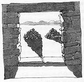
southern faces, with long views. Tsankawi, overlooking the Rio Grande valley, is my favorite example, partly because it has real cave-dwellings, not merely dwellings built under a cliff overhang. There were some large blow holes in the lava, creating various nooks and crannies in the cliff face. And the lava is soft enough that some nooks were enlarged to form nice rooms with shaped doorways. And there is a square cave, no less. In the westernmost cave on the path, they squared up the room and plastered the lower half of the walls in the manner that one sees in kivas. Over the T-shaped Anasazi doorway, with its notches for a lintel (probably a "curtain-rod" pole that held an animal skin to cover the opening), is a long, narrow hole drilled through the rock (perhaps a natural hole that was reamed out). This opening faces south, and at midday a spotlight of sunlight moves across the floor of the room. In midwinter, the spotlight would pass along the foot of the back wall of the room (so far as one can tell, without knowing how deep a layer of dirt now covers the original floor). |
|
HOPI INDIAN RESERVATION is centered on three large mesas in northeastern Arizona. The
Hopi’s mesas bear little relation to well-defined round or rectangular "tables" such as Acoma or
Masada. Rather, they are southern "fingers" of Black Mesa to their north, peninsulas in the sky
once again. At the southern edge of each finger, the land falls away to the south, creating a
splendid vista. But elsewhere, the high land is undulating and the views are limited. It is mostly
dry, high desert; the interesting features are along its edges. The hillsides force upward some of the warm, moist air that blows northwest from the Gulf of Mexico. As this air cools, it becomes too saturated to hold onto its moisture. The summer rainfall from the monsoons is why the Anasazi probably liked this place and other such south-facing hills. Such hillsides get what rain there is in this land of low rainfall and recurrent drought. The Hopi farmers grow their blue corn in stream beds where the water is channeled; whenever one drives over a little gully, one can look down from the bridge and probably spot a plot of Hopi corn, each plant carefully tended by hand. The stream bed may look dry, but the sandy bottom is likely to have some water beneath the sun-baked surface. The hillsides are a more chancy proposition, and the Hopi farmer plays his chances in an interesting way. While the sides of the mesas catch the summer rainfall more reliably than the lowlands and the high country, a Hopi farmer will plant some crops at the bottom of a mesa, some halfway up, and the rest up on top. The top fields will get the rainfall that precipitates out as monsoon clouds drifting north are pushed up to high altitudes each summer day. In a bad year, the fields at the base will get little rainfall and the crops there will fail; the plots halfway up will be stunted, but the top fields will still yield a crop. In a good year, all three sets of fields will prosper. It’s called "spreading your bets," a practice often ignored by modern farmers who specialize in one high-paying crop and then suffer the pests and diseases promoted by the monoculture conditions (the Irish potato famine comes to mind).
|
|
NO ISOLATED DWELLINGS dot the Hopi’s land, as one would typically see in the Navajo’s
land that surrounds the Hopi reservation. The Hopi mostly live in compact villages, and hike out
to tend their scattered plots (though the pickup truck has served to shorten the hike these days). One thing that the Navajo did not borrow from the Pueblo Indians was this tendency to cluster; I have a hard time imagining a group of Navajo families taking up residence in the confines of a cliff-dwelling, though it would probably seem familiar and comfortable to the Hopi (though a little odd, having a dome over one’s homes). The Navajo’s tendency is to spread out, to establish themselves in distant gullies at the end of a long rutted road, build a hogan, and raise a large family there (one is reminded of the European pioneers settling the West). This has had implications for population size, and is one reason why the notion of the Navajos and Hopi sharing a "joint use area" surrounding the Hopi Reservation proper didn’t work out (it finally had to be partitioned, causing some Navajo "pioneers" to be evicted). The Navajo are expansionistic, while - one tends to hypothesize - the Pueblo people’s population stabilizes around the size that a traditional village site can accommodate. Though there are some exceptions, Hopi villages are often located on those long southern fingers of Black Mesa. Walpi stands high above the highway which skirts the southern edge of First Mesa, looking like a knife-edge version of an Italian hill town such as Assisi. Acoma has cliffs all around, but those of Hopi are half again as high, totaling about 45 stories tall. One suspects that the Hopi built atop these windswept, waterless ridges not so much for practicality but because these places were somewhat like those where their legendary ancestors lived, settings embedded into the Anasazi cosmology.
|
|
THE HOPI’S CALENDAR appears, at first glance, to be the usual amalgam of lunar and solar
events that characterized calendars before our modern calendar simplified things somewhat.
Various North American Indians learned to add a thirteenth lunar month every three years to
bring the calendar back into synchronization with the seasons. While the phases of the moon are merely footnotes to a modern calendar, they used to be an integral part of things, and still are used in setting the dates of religious festivals. The day on which Easter occurs, for example, is the first Sunday following the first full moon after the spring equinox. Thus it is first keyed to the solar cycle of the seasons (the equinox must have happened), then to the monthly maturation of the moon, and finally to the notion of when the week begins (and weeks are not keyed to anything, Sunday drifting with respect to full moon, New Year’s Day, the equinoxes, etc.). The Easter arrangement sounds suspiciously like a compromise solution to an ancient argument between opposing religious factions.
Most Hopi festivals are keyed to a similar combination of solar and lunar events - but their
highest festival, Soyal, is about as close to the day of the winter solstice as they can make it by
observation of the sunrise and sunset on the horizon. The date of Soyal each year is determined
by a village elder called the tawa-mongwi or Sun Chief. Standing at a favorite observation spot
on Second Mesa, he carefully observes sunset over the San Francisco Peaks, surely the most
prominent landmark visible from their high plateau. When sunset reaches a characteristic
position about ten days before its extreme southwestern position, he announces that Soyal is ten
days hence, and preparations begin. The Zuni tell this story about the first sun priest:
Sun watching goes on year-around, not just near the solstices. You can see a big advantage to using a horizon-based calendar for an agricultural people, especially when it comes to judging planting time. Late frosts in the spring may kill vulnerable new sprouts and frosts are again a problem as harvest time approaches. The frost-free growing season for Hopi corn is about 120-130 days and, because of the altitude, that means that there no weeks to spare in many places: planting at the right time is crucial. Too late means having to harvest when the ears of corn lack full maturity; too early means that the frost may kill the sprouts. As even amateur gardeners know, sniffing the air on the first fine day of spring is not the way to decide when to plant. The accumulated wisdom of farmers had to be keyed to something besides the phases of the moon, which are ten days earlier the next year. Obviously, one wants to key to the cycle of the seasons, i.e., the sun.
We naturally think that counting 365 days a year should solve the problem. But no law says that
the earth must rotate on its axis at a rate that fits with the rotation around the sun. The earth
rotates 365.24 times on its axis during each orbit about the sun (the earth used to spin faster on
its axis, getting in more than 400 days in a year, but the rotation has slowed down since
Precambrian times, thanks to the back-and-forth motion of tides). Leap years are one way to
correct for this lack of an integer number of days in a round trip around the sun, but were not
invented until 46 B.C. A far simpler calendar, with none of these complications, is to use the
position of the sunrise on the horizon. It is perfect for determining the time to plant.
Even if you do not have a convenient mountain peak to mark sunrise on the right day of the year, you can construct rock cairns to the east of your front door: Each year, you make a pile of rocks (a shrine, if you like) on the day that you start planting, located right on the path from your front door to the sunrise. If it turns out to be a bad year for corn, you go out and kick down the offending cairn. For the rock piles, it’s the survival of the fittest. After a decade of this, only the cairns for the good years will remain - and then you can start using sunrise behind the tallest cairn as your indicator of when it is best to start planting. Since horizon calendars have none of the drift problems of lunar-solar calendars or our present day-counting calendars, this "primitive" calendar seems quite trouble-free, perfect for a settled people who do not travel very far from home. Judging by the way agricultural instructions are embedded in Pueblo religions, such directions became part of religious tradition.
|
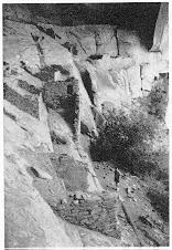
THE NEXT WINTER, I returned a few days after the solstice and photographed Betatakin from
the visitor’s overlook across the canyon, from which I first admired the bandshell shape. When I
arrived, the sun was already casting an oblique shadow of the roof line; it fell diagonally across
the sloping floor of the bandshell. The shadowline clearly showed the corner-shaped notch, far
back up behind the ruins. I watched the notch slowly sweep down, crossing the alcove as the sun
rose in the sky and moved south.
I am happy to report that the notch’s shadow passed directly through the kiva (it’s always nice to verify that your observation technique and computer program are not fooling you). Winter solstice observers at the kiva would indeed have seen the sun rise near that notch of the overhang. I doubt that they would have framed the sun atop the step - when the sun is so high in the sky, it is simply too bright to look at. Perhaps they obscured the rising sun behind the outcrop, in the manner of Perfect Kiva’s rounded downstep. And sidestepped their way along that east-west path to the kiva entry, in the weeks before winter solstice? So Betatakin’s kiva definitely has a solstice view, even if the crescent corners of sky fail to celebrate the winter solstice in the manner of Split-Level Ruin. Building a kiva to align with winter solstice is not simply analogous to building a mosque to face Mecca; yes, the architecture is what remains, but it was presumably part of a process in the same way that a scientific apparatus is part of a scientific practice. The priests have a lot of observational work to do for the winter solstice. That the Sun Priest is expected to schedule the celebrations on exactly the right day has an interesting consequence: if his prediction is inaccurate, he is blamed for everything that goes wrong during the following year. If a child dies, or the rains don’t come, or the crops fail, it’s his fault. The Sun Priest may not be executed by an unhappy emperor, as happened to those Chinese astronomers who failed to predict the solar eclipse in 2134 B.C., but he’s still very motivated to avoid mistakes in observations and calculations. And how might someone have known that Soyal was celebrated on the wrong day? Just use some other horizon feature that the sun passes several weeks before the solstice, and count the days until the sun returns to it; the solstice turnaround should have been exactly midway through the period. Division is not necessary: just create a string of beads with the passing days, using a special bead for the day that Soyal was celebrated. When the necklace is completed by the return of the sun to the horizon feature, hold up the string by the Soyal bead so that the two halves dangle down. There should be an equal length of beads on each side, if Soyal were correctly celebrated. Such were the prehistoric motivations for doing better and better science? A little ability to predict the future, even something as routine as the turnaround of the seasons, has enormous consequences for the role of the prophet-scientist in society - it starts a clock running, in the minds of others, and often a scoreboard. Becoming a prophet carries both opportunities and risks.
|